Architectural Drawings | The Figure Ground
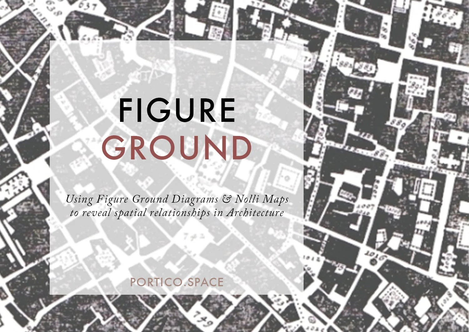
Figure-ground drawings show the relationships between positive and negative spaces, solids and voids, or shadows and light.
INTRODUCING THE FIGURE GROUND
In this post, I'm going to share with you everything you need to know to get started with figure ground drawings.
This includes:
what a figure ground drawing is in art and architecture,
why you would use a figure-ground drawing;
a range of architectural examples including the famous 'Nolli Map'; and finally
how you can make your own figure ground drawing.
WHAT IS FIGURE GROUND DRAWING?
The definition of a figure ground drawing, simply put, is any drawing which uses contrast to show the relationships between positive and negative spaces, solids and voids, or shadows and light.
In art practice
In art practice, a figure ground drawings focuses on the visual relationship between foreground and background. Artists play with these relations, investigating questions such as: How do viewers perceive a difference? How do edges affect the images we see? How do we make sense of the spaces in a drawing?
In Architecture
In architecture, figure-ground drawings are useful for showing how the material or solid components of buildings relate to the spaces contained by the built form. Figure ground drawings in architecture are often applied at an urban scale, as a way of drawing the plan of a city. But, they can also be useful at the scale of an individual residence, or even as a technique for drawing objects such as furniture pieces within a space.
Figure
In architecture , positive spaces are solids, the things which have a physical presence in space: buildings, walls, chairs and tables.
ground
Negative spaces are the spaces around the figures: the air in the room, the gaps between neighbouring buildings, the open streets and parks of the city.
WHY USE A FIGURE-GROUND DRAWING?
If you are trying to understand a city neighbourhood, a figure ground drawing can be a great place to start. Not only are they fairly easy to produce, they are very clear and can reveal many aspects of how a space works which are often hidden in more complex drawings, where lines compete with space.
You CAN use a figure-ground drawing to:
reveal the extent and continuity of open space;
examine the basic frameworks at play - e.g. in an urban context, the street grid systems; in a house, the solid walls; or in a room, the immovable furniture pieces;
understand the edge conditions between positive and negative: is it a harsh, straight line? does it meander? are there ‘nooks’?
understand how a proposed building or space might interact with the existing fabric of the neighbourhood, particularly in terms of the mass, proportions and edge conditions.
Examples of Figure Ground Drawings
in Architecture
The Nolli Map (1748)

Crop of the Map of Rome
Giambattista Nolli, 1748
The most famous architectural example of a figure ground drawing is the Map of Rome produced by Giambattista Nolli in 1748 - now commonly known as the 'Nolli Map'. For this reason, particularly in architecture circles, you might find a Figure Ground drawing being referred to as a 'Nolli Map'.
The map is most famous for convincingly communicating the idea that a city can be experienced as a series of spaces, rather than a series of objects. To communicate this through drawing, Nolli decided to show the interiors of churches as open, public space - drawing them, or not drawing them, as negative space, exactly the same as the public streets and access ways around the buildings. The result? The streets seem to flow into the cavernous naves of the various churches, giving a sense of how publics understood and occupied the city at the time.
You can access an incredible interactive digital version of the map produced by the University of Oregon here.
THE NOLLI MAP OF LAS VEGAS (1972)

Crop of the Nolli Map of Vegas
from Learning from Las Vegas
Robert Venturi & Denise Scott Brown
In 1972, American Post-modern architects Robert Venturi and Denise Scott Brown carried out an architectural study of Las Vegas, which was published in a book titled ‘Learning from Las Vegas.’ As part of their work, they produced the ‘Nolli Map of Las Vegas.’
In this Figure Ground drawing, Venturi and Scott-Brown isolated and separated out several different layers of information about ‘The Strip’ - generating ‘an intriguing crosscut of Strip systems.’ The different ways they reassembled this information allowed a range of meanings to be extrapolated and connections to be drawn. Here, the Nolli Map is called on to invert the conventional readings of space.
OTHER EXAMPLES...
Jim Dine is one of a number of artists who push the boundaries of the figure-ground technique to great effect in their work.
Architect and Architectural Theorist Stan Allen's 'Diagrams of Field Conditions' expand on and interrogate the figure-ground technique. Stan Allen writes: 'One of the potentials of the field is to redefine the relation between figure and ground.'
Figure-ground drawings are also extended in the field of Space Syntax, which encompasses a range of theories and techniques for analysing space. You can find out more about the Bartlett Space Syntax Laboratory here.
How to make your own
figure-ground drawings
The methods
Figure-ground drawings can be fairly easy to put together. If you are drawing by hand, the easiest method is tracing - using a semi-transparent sheet such as butter paper, tracing paper or vellum to overlay on an existing, printed to scale map, and then picking out certain parts to hatch in.
On the computer, this process can either be simulated within a CAD programme (such as Autocad, Archicad, Revit or Vectorworks) by isolating certain layers, simplifying what is visible, and adding hatched. You can often download building footprints in dwg format from Council websites as a starting point.
Alternatively, you can use Adobe products to post-produce the drawing from a base template - my pick here would be Illustrator.
Things to think about BEFORE YOU START
Whichever method you choose, the fundamentals remain unchanged. To make your own figure-ground drawing, you should:
Start from a good map. While figure-ground drawings may not appear particularly detailed, the more detail you begin with, the more interesting the outcome will be visually. This of course depends on the scale you are dealing with..
Consider the Scale. Always draw to scale. Pick a scale which best allows you to investigate and/or communicate the what is important to you. Interested in the proximity of public spaces? Zoom out. Interested in doorways? Zoom in. It seems obvious, but is often forgotten!
Define your value system. What is the point of your drawing? What are you aiming to find out or communicate by making this drawing?
Figure out your positives & negatives. What should be shown as positive? What should be negative? Be concise and consistent. Setting out the rules clearly for yourself before you start will save you time and confusion later.
Plan your technique. How will you show each? Poche? Hatching? Colour? Will you interweave any other techniques?
Be aware of your lines. What is the role or line or outline? If you don’t want outlines, you may need to draw a base drawing first, that you can trace over to fill in the solids and voids.
are you inspired? have you used a figure-ground drawing before? i’d love to hear your thoughts down in the comments!
I'd also love to hear your experience with figure-ground drawings, and if you have any examples or personal work you think should be included on our pinterest board, let us know.

Scale allows us to understand the relationship between a representation - a drawing or model - and reality. Being able to draw accurately to scale, and to shift fluidly between scales, is one of the most important aspects of architectural drawing and spatial design.